Geography and Location
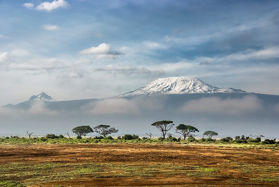
Kilimanjaro is located in northeastern Tanzania, close to the border with Kenya. It sits near the equator, which makes its icy summit especially surprising. The mountain rises dramatically from the surrounding plains, with almost no foothills leading up to it. This makes Kilimanjaro the tallest free-standing mountain in the world, a title that sets it apart from peaks like Mount Everest, which are part of long mountain chains.
A Volcano with Three Cones
Mount Kilimanjaro is actually a dormant stratovolcano made up of three separate volcanic cones. The highest cone is called Kibo, and it contains the famous crater at the very top called Uhuru Peak. The second cone, Mawenzi, is jagged and dramatic, while the third cone, Shira, is the oldest and has mostly collapsed over time. Scientists believe Kilimanjaro last erupted roughly 360,000 years ago, and while Kibo could potentially erupt again, there are no signs of activity right now.
Five Climate Zones
One of the most amazing things about Kilimanjaro is that climbers pass through five completely different climate zones on their way to the top. At the base, farmers grow crops like bananas and coffee in the warm, fertile soil. Higher up, thick rainforest filled with monkeys and exotic birds surrounds the mountain. Above the forest comes a zone of heath and moorland with strange-looking giant plants. Next is a barren alpine desert with very little life. Finally, at the summit, climbers reach an arctic zone of ice and snow, even though the mountain is near the equator.
Climbing Kilimanjaro
About 50,000 people attempt to climb Mount Kilimanjaro every year, and roughly 65% of them reach the summit. Unlike many tall mountains, Kilimanjaro does not require technical climbing skills such as ropes or ice axes for most routes. However, altitude sickness is a serious danger because the air gets very thin near the top, making it hard to breathe. The first people known to reach the summit were German geographer Hans Meyer and Austrian mountaineer Ludwig Purtscheller, who made it to the top in 1889.
Melting Glaciers
The famous glaciers and ice fields near the top of Kilimanjaro are disappearing at an alarming rate. Scientists estimate that the mountain has lost about 85% of its ice cover since 1912. Researchers believe this is caused by a combination of climate change and reduced snowfall over many decades. If the ice continues to shrink at this pace, some scientists predict Kilimanjaro’s glaciers could vanish entirely within a few decades, changing the mountain’s appearance forever.
Protection and Conservation
Kilimanjaro National Park was established in 1973 to protect the mountain and its unique ecosystems. In 1987, the park was named a UNESCO World Heritage Site because of its outstanding natural importance. The park covers about 1,688 square kilometers and includes the entire mountain above the tree line as well as surrounding montane forest. Park rangers and conservation groups work to manage the tens of thousands of visitors each year while protecting the fragile habitats on the mountain’s slopes.
Why Kilimanjaro Matters
Mount Kilimanjaro is more than just a tall mountain. It is a powerful symbol of Africa and a source of water for millions of people who live in the surrounding region. Rivers fed by Kilimanjaro’s melting ice and rainfall support farms, villages, and wildlife across Tanzania and Kenya. The mountain also draws visitors from around the world, creating jobs and income for local communities. As its glaciers shrink, Kilimanjaro serves as a visible reminder of how climate change affects even the most iconic places on our planet.